
Sand Mining Watch
“Sand resource governance is one of the greatest sustainability challenges of the 21st century.”
Sand Mining Watch is a set of open-source tools which enables the production of high-resolution, real-time maps of sand mining activity in river basins across the world.
Across the world, excessive (and often illegal) sand mining in rivers is creating numerous environmental and social crises. By automating the detection of sand mining activity in near-real time, Sand Mining Watch offers a pathway to improving monitoring, transparency and accountability, and can inform policy-making.
We are supported in our work by the Mozilla Foundation (Mozilla Technology Fund: Open-Source AI for Environmental Justice, 2024 Cohort), and the Center for Effective Global Action (CEGA).
Our model uses knowledge & data from India Sand Watch (ISW), and we are currently piloting and evaluating our results in India in collaboration with ISW / Veditum India Foundation.
Characterize scope and scale of sand mining in India
Assess sand mining activity in restricted zones / near critical infrastructure
Evaluate the effectiveness of current national and state regulations
Gain insight into the socio-economic impacts of sand mining
Sand Mining In India
Take a look at images from our recent field trip, where we visited a number of sand mining sites across India, including the states of West Bengal, Rajasthan, Madhya Pradesh and Uttar Pradesh. Most of the mines we observed are likely to be in violation of existing regulations.
These field visits were made possible by Veditum India Foundation and Human Environment Alliance League (HEAL). We are also grateful to Tarun Nair and the Wildlife Conservation Trust.

A sand mine in Chambal National Sanctuary. Officially, all mining activity is banned within the sanctuary; despite this, the extraction of sand continues unabated and unchecked. This particular site used to be a nesting site for critically endangered Indian Gharial. (Picture Credit: Tarun Nair / Wildlife Conservation Trust)

A relatively small (and illegal) sand mine (~25Ha) in the same region. Over its lifetime, even a small mine like this can generate upto USD 21 Million in revenue (at current prices). Note that the access road to the mine goes past the local political representatives’ office. In the bottom right inset you can see close to 20 gharials basking in the sun. Despite its ecological significance, legal protection and exposure, monitoring / enforcement appears to be completely absent at this site, as is the case in many parts of India. (Picture Credit: Tarun Nair / Wildlife Conservation Trust)

A sand mine within a restricted zone, i.e. within 500 meters of critical infrastructure. In the background you can see two important bridges joining the states of Rajasthan and Madhya Pradesh, as well as multiple water intake points that provide drinking water supply to nearby cities. (Picture Credits: Tarun Nair / Wildlife Conservation Trust)
Browse through the gallery below for pictures from various mining sites in West Bengal.


Sand Mining signatures In Satellite Imagery
Below, you can find some interactive examples of what sand mining looks like at different locations across India, as seen in satellite imagery. Keep an eye out for the scarring and pitting patterns in these images, which are highly indicative of sand mining activity. You can also see some of the machinery and vehicles commonly used at mining sites.
Feel free to zoom around and get a feel for the scale of these highly destructive practices.
The timelapse below covers a period of 1.5 years on the Kathajodi river, just outside the city of Cuttack (Odisha, India). Note how the scarring / pitting patterns grow and change over time. In addition to mining, these patterns are influenced by natural changes in the water level, and the deposition and erosion of sediment. In this part of the Indian subcontinent, the monsoons play a strong role by providing seasonal flooding of most rivers in the subcontinent.
Methods
We combine deep learning models with freely available multispectral satellite imagery (Sentinel-2) to detect sand mining activity in river basins across the world. For the full details please refer to the paper in the publications section and the code in Github.
We are currently evaluating the performance of our models in India.
Publications
We have presented some of our early results at conferences and workshops (see below). More to follow soon!
NeurIPS 2023 Workshop On Tackling Climate Change with Machine Learning (2023). Ando Shah* , Suraj R. Nair*, Tom Böhnel, Joshua E. Blumenstock. NeurIPS | CCAI
IEEE IGARRS 2024. Ando Shah*, Suraj R. Nair*, Tom Böhnel, Joshua E. Blumenstock
denotes equal contribution
Frequently ASKED Questions
What is sand mining?
Sand is a crucial building block of modern life — it is a key component of concrete, asphalt and glass. It also plays an important in delivering ecosystem services, and in maintaining the health of our wetlands.
“Sand mining” primarily refers to the extraction of construction grade sand from rivers and beaches across the world. In recent years, spurred by growing urbanization and economic growth, the demand for such sand has skyrocketed. This has resulted in excessive (and mostly illegal) mining in rivers and beaches across the world — resulting in devastating ecological and social consequences. Today, sand is the second most extracted resource on the planet, after water. Demand for sand is steadily growing, especially in the global south, due to its pervasive use in concrete and asphalt.
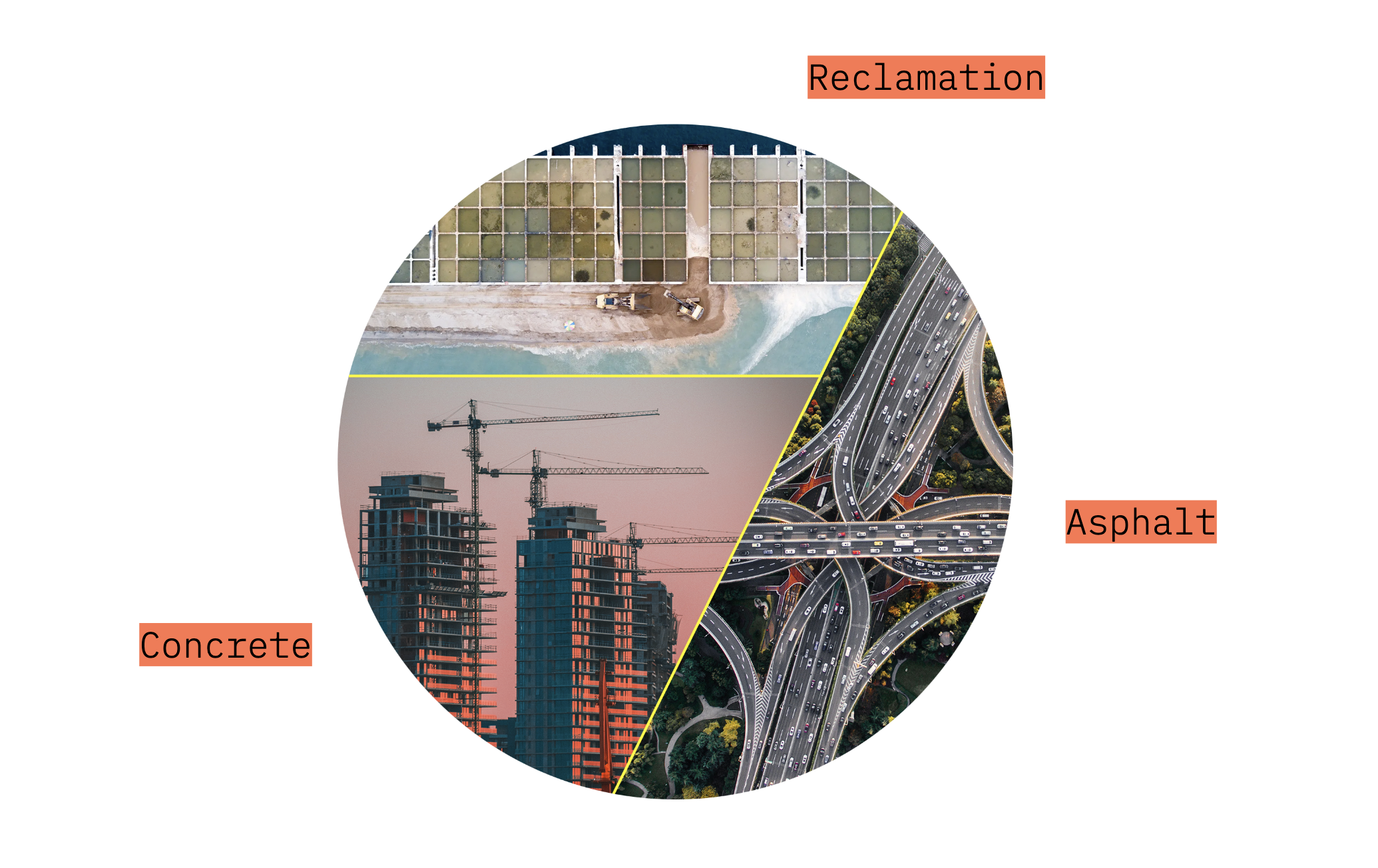
Drivers of sand mining: Concrete is about 70-80% sand and gravel; asphalt is about 90% sand.
Where does sand mining take place? Is it a serious issue only in India?
Excessive and unregulated sand mining is a global issue, and a serious concern in South and South-east Asia, Sub-Saharan Africa, and Latin America.
How does Sand Mining Watch address this?
In India (and other parts of the world), a persistent data gap prevents us from characterizing the true scale and extent of sand mining, and from understanding it’s environmental and socio-economic impacts. Physical monitoring is impossible, since we’re talking about millions of square kilometers of river banks. Sand Mining Watch aims to plug these gaps by building tools which allow us to observe sand mining activity using satellite imagery….
Aren’t there tools out there which already do this?
There are plenty of resources and tools which use satellite imagery and machine learning to examine mining activities across the world. However, most of these tools focus on the mining of precious minerals, and tend to ignore/ exclude sand mining as a category of interest. Sand mining also presents a unique detection challenge, since it takes place in riverbeds and riverbanks — sites that undergo many physical changes over the course of a year, as a result of the natural hydrological cycles (See the Figure below for more intuition on what these changes look like).

Acknowledgements
We are supported a fantastic group of research assistants (listed in alphabetical order)
Aarabhi Achanta
Tom Boehnel
Sushant H Vema
Irene Widiaman
Gautam Sai Yarramreddy